Content Information Type Specification for Digital Geospatial Data Records Archiving
Preface
I. Aim of the Specification
This document is one of several related specifications which aim to provide a common set of usage descriptions of international standards for packaging digital information for archiving purposes. These specifications are based on common, international standards for transmitting, describing and preserving digital data. They also utilise the Reference Model for an Open Archival Information System (OAIS), which has Information Packages as its foundation. Familiarity with the core functional entities of OAIS is a prerequisite for understanding the specifications.
The specifications are designed to help data creators, software developers, and digital archives to tackle the challenge of short-, medium- and long-term data management and reuse in a sustainable, authentic, cost-efficient, manageable and interoperable way. A visualisation of the current specification network can be seen here:

Figure 1: Diagram showing E-ARK specification dependency hierarchy. Note that the image only shows a selection of the published CITS and isn’t an exhaustive list.
Overview of the E-ARK Specifications
Common Specification for Information Packages (E-ARK CSIP)
This document introduces the concept of a Common Specification for Information Packages (CSIP). The main purposes of CSIP are to:
- Establish a common understanding of the requirements which need to be met to achieve interoperability of Information Packages.
- Establish a common base for the development of more specific Information Package definitions and tools within the digital preservation community.
- Propose the details of an XML-based implementation of the requirements using, to the largest possible extent, standards which are widely used in international digital preservation.
Ultimately the goal of the Common Specification is to reach a level of interoperability between all Information Packages so that tools implementing the Common Specification can be adopted by institutions without the need for further modifications or adaptations.
Specification for Submission Information Packages (E-ARK SIP)
The main aims of this specification are to:
- Define a general structure for a Submission Information Package format suitable for a wide variety of archival scenarios, such as document and image collections, databases or geospatial data.
- Enhance interoperability between Producers and Archives.
- Recommend best practices regarding the structure, content and metadata of Submission Information Packages.
Specification for Archival Information Packages (E-ARK AIP)
The main aims of this specification are to:
- Define a generic structure of the AIP format suitable for a wide variety of data types, such as document and image collections, archival records, databases or geospatial data.
- Recommend a set of metadata related to the structural and the preservation aspects of the AIP as implemented by the eArchiving Reference Implementation (earkweb).
- Ensure the format is suitable to store large quantities of data.
Specification for Dissemination Information Packages (E-ARK DIP)
The main aims of this specification are to:
- Define a generic structure of the DIP format suitable for a wide variety of archival records, such as document and image collections, databases or geographical data.
- Recommend a set of metadata related to the structural and access aspects of the DIP.
Content Information Type Specifications (E-ARK CITS)
The main aim of a Content Information Type Specification (CITS) is to:
- Define, in technical terms, how data and metadata must be formatted and placed within a CSIP Information Package to achieve interoperability in exchanging specific Content Information.
The number of possible Content Information Type Specifications is unlimited. For a list of existing Content Information Type Specifications see the DILCIS Board webpage (DILCIS Board, http://dilcis.eu/).
II. Organisational Support
This specification is maintained by the Digital Information LifeCycle Interoperability Standards Board (DILCIS Board, http://dilcis.eu/). The role of the DILCIS Board is to enhance and maintain the draft specifications developed in the European Archival Records and Knowledge Preservation Project (E-ARK project, http://eark-project.com/), which concluded in January 2017. The Board consists of eight members, but no restriction is placed on the number of participants taking part in the work. All Board documents and specifications are stored in GitHub (https://github.com/DILCISBoard/), while published versions are made available on the Board webpage. The DILCIS Board have been responsible for providing the core specifications to the Connecting Europe Facility eArchiving Building Block https://ec.europa.eu/cefdigital/wiki/display/CEFDIGITAL/eArchiving/.
III. Authors & Revision History
A full list of contributors to this specification, as well as the revision history, can be found in the Postface material.
CITS Geospatial
Content Information Type Specification for Digital Geospatial Data Records Archiving
Version: 3.0.0
Date: 2024-12-13
1. Context
1.1. Purpose
1.2. Scope
1.3. Information Package Layered data model
2. CITS Geospatial requirements structure
2.1. Folder structure requirements
2.2. METS Requirements
2.2.1. Package and Representation METS
2.2.2. Package METS requirements
2.2.3. Representation METS requirements
2.3. Data requirements (Geospatial data)
2.3.1. Geodata general - requirements
2.3.2. Vector Geodata - requirements
2.3.3. Raster Geodata - requirements
2.3.4. Non-spatial data - requirements
2.3.5. Long Term Preservation Format Profiles
2.3.6. Other Geospatial data
2.4. Documentation requirements
2.4.1. Structure of geospatial records
2.4.2. Rendering and visualisation
2.4.3. Behaviour - Software and algorithms
2.4.4. Coordinate reference system information- requirements
2.4.5. Other - Contextual Documentation requirements
2.5. Geospatial Metadata requirements
3. Glossary
4. Appendices
4.1. Appendix A: E-ARK Information Package METS Examples
4.1.1. Example 1: Example of a whole METS document describing an representation following CITS Geospatial.
4.1.2. Example 1: Example of a whole METS document describing an submission information package following CITS Geospatial.
4.2. Appendix B: External Schema
4.2.1. E-ARK SIP METS Extension
4.2.2. E-ARK CSIP METS Extension
4.3. Appendix C: External Vocabularies
4.3.1. IANA media types
4.3.2. Content information type specification
4.3.3. File group names
4.3.4. Structural map label
4.3.5. Structural map typing
4.3.6. Note type
4.3.7. Content Category
4.3.8. ISO language codes
4.3.9. Alternative record ID's
4.3.10. dmdSec status
4.4. Appendix E: E-ARK CITS-Geospatial Metadata Requirements
4.4.1. E-ARK GEospatial representation METS Profile 1.0 (citsgeospatial_v3_0) Requirements
4.4.2. E-ARK Geospatial root METS Profile 1.0 (citsgeospatial_v3_0) Requirements
1. Context
1.1. Purpose
The purpose of this document is to describe the Content Information Type Specification for Geospatial records (CITS Geospatial). This specification describes how to package files containing geospatial records in a CSIP package(s) and the extension of the E-ARK SIP. It is designed to be used for the transfer of different types of Geospatial records and resources to and from archives.
NOTE: Throughout this document the acronym CSIP will be used to describe the combination of CSIP and SIP.
1.2. Scope
Geospatial records are any digital records that describe an object in space using coordinates based on a geographic coordinate system and a set of descriptive elements called attributes. They are created in many different proprietary formats but mostly come in two forms, vector data (points, lines, polygons) and raster data (sets of one or multiple arrays of pixels).
The CITS Geospatial specification scope describes how geospatial data files, metadata files, schema files for validation, documentation, and other files should be placed and structured into the CSIP based structure when producing a CITS Geospatial SIP for transfer to long-term preservation.
This specification is general enough to support multiple types of geospatial records (not only vector and raster-based records). Therefore, the specification does not define mandatory long-term preservation formats. Instead, it provides a possibility of extensions, the so-called [Long-term preservation format Profiles]{.underline}, that need to comply with general requirements. Examples of such Profiles for vector data (GML) and raster data (GeoTIFF) are provided in the Guideline that accompanies this document. An example of a Profile for GIS in its own guideline which also accompanies this document. Profiles for other geospatial records formats (like proprietary data, earth observations, point clouds, oblique images, web services, etc.) are not proposed at this stage. They will be added later in cooperation with the geospatial community.
Description of the two accompanying guidelines:
-
The first accompanying guideline document (Guideline for the specification for the E-ARK Content Information Type Specification for Geospatial data (CITS Geospatial)) provide a basic introduction to the field of geospatial data and the concepts used in this specification. In the Guideline there is also a description of the Profile for using the INSPIRE directive, with the CITS Geospatial both as the content being transferred and how to map INSPIRE information to an archival finding aid.
-
The second guideline document (Guideline for using the specification for the E-ARK Content Information Type Specification for Geospatial data (CITS Geospatial) with GIS) provides the information on how to extend the first accompanying guideline document with content describing preservation of selected elements from Geographical Information Systems (GIS). The guideline aims to extend the scope of preservation beyond the geospatial data records themselves and focus more on GIS elements defining the geospatial information products.
A glossary for archival and geodata terms to facilitate the readability of the specification is present at the beginning of this document.
1.3. Information Package Layered data model
This section introduces the role of the CITS Geospatial and its dependencies on basic structures of the Information package.
This specification is created based on the requirements of the Common Specification for Information Packages (CSIP) and the Specification for Submission Information Packages (E-ARK SIP). To fully understand its requirements, we highly recommend that users learn and understand the requirements and the terminology of the initial documents, before using this specification.
The data model structure is based on a layered approach for information package definitions (Figure 2). The Common Specification for Information Packages (CSIP) forms the outermost layer.
The general SIP, AIP and DIP specifications add submission, archiving and dissemination information to the CSIP specification.
The third layer of the model represents specific Content Information Type Specifications (CITS), such as this CITS Geospatial specification.
Additional layers for business-specific specifications and local variant implementations of any specification can be added to suit the needs of the organisation.
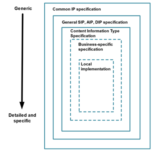
Figure 1: Data Model Structure
Every level in the data model structure inherits metadata entities and elements from the higher levels. In order to increase adoption, a flexible schema has been developed. This will allow for extension points where the schema in each layer can be extended to accommodate additional information on the next specific layer until, finally, the local implementation can add specific entities or metadata elements to satisfy very specific local needs. Extension points can be implemented by:
-
Embedding foreign extension schemas (in the same way as supported by METS http://www.loc.gov/standards/mets/ and PREMIS http://www.loc.gov/standards/premis/. These support both increasing the granularity of existing metadata elements by using more detailed data structures as well as adding new types of metadata.
-
Substituting metadata schemas for standards more appropriate for the local implementation.
The structure allows the addition of more detailed requirements for metadata entities, for example, by:
-
Increasing the granularity of metadata elements by using more detailed data structures, or
-
Adding local controlled vocabularies.
For consistency, design principles are reused between layers as much as possible.
2. CITS Geospatial requirements structure
The Content Information Type Specification for Geospatial data aims to define the necessary elements required to preserve the accessibility and authenticity of geospatial records over time and across changing technical environments. To achieve this, this specification defines the categories of significant properties [Source: https://significantproperties.kdl.kcl.ac.uk/ ] for geospatial records to allow the digital geospatial information products to remain accessible and meaningful. For every geospatial record or a set of records, we need to preserve information that suits the following categories:
-
Content: Information contained within the Information Object. For example, location information (coordinates, orientation, pixel size), geometry, related feature attributes, etc. This is stored within the
Datafolder within a Representation. -
Context: Any information that describes the environment in which the content was created or that affects its intended meaning. Examples: Creator name, date of creation, spatial accuracy, source data, sensor information, etc. This type of information can be provided using the
Otherfolder within the mainDocumentationfolder or by providing various Geospatial Metadata located within the RepresentationMetadata/Descriptivefolder. -
Structure: Information that describes the extrinsic or intrinsic relationship between two or more types of content, as required to reconstruct the performance. For example, a Raster object and its connection to the world file, or a vector dataset combined with a table, a GIS project, defining the structure of geodata layers used to create a map, configuration of web services, defining a mash-up WMS, etc. This information should preferably be provided using standardised machine-readable files or at least in written documentation.
-
Rendering: Any information that contributes to the recreation of the performance of the Information Object. Example: Colour map of pixel values of a raster; Styled Description layer for web services, documentation describing a cartographic map project, Report designs, etc.
-
Behaviour: Properties that indicate the method in which content interacts with other stimuli. Example –rendering algorithms, analysis functionalities, standard transformation processes, documentation of original system functionality, user manuals, training materials, system usage videos, etc.
Figure 2: CITS Geospatial extension folders for Information Packages
2.1. Folder structure requirements
The CITS Geospatial information structure inherited its package structure from the E-ARK Common Specification for Information Packages (CSIP) (blue elements), and it is an extension of it (green elements).
A visualisation of a valid CITS Geospatial Information Package is illustrated in Figure 3. This Figure shows an example of a simple valid Information Package with one representation of a single vector dataset in a GML file format.
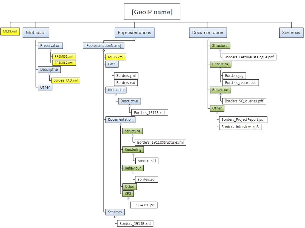
Figure 3: Example Information Package folder structure
The folder structure in CSIP described in section https://earkcsip.dilcis.eu/#folderstructureofthecsip is extended with the following geo specific requirements on the folder structure:
GEOSTR1: XML schema documents for any structured descriptive geospatial metadata within package MUST be placed in a sub-folder called schemas within the Information Package root folder and/or the representation folder. This requirement is an extension of CSIPSTR15.
GEOSTR2: A documentation folder on package or representation level SHOULD include a subfolder named structure. This requirement is an extension of CSIPSTR16.
GEOSTR3: A documentation folder on package or representation level SHOULD include a subfolder named rendering. This requirement is an extension of CSIPSTR16.
GEOSTR4: A documentation folder on package or representation level SHOULD include a subfolder named behaviour. This requirement is an extension of CSIPSTR16.
GEOSTR5: A documentation folder on package or representation level SHOULD include a subfolder named CRS. This requirement is an extension of CSIPSTR16.
GEOSTR6: A documentation folder on package or representation level SHOULD include a subfolder named other. This requirement is an extension of CSIPSTR16.
2.2. METS Requirements
2.2.1. Package and Representation METS
Generally, CSIP can consist of zero to many representations, and this is an important feature that needs to be considered when packing geodata files within CSIPs.
There can easily be different representations of the same geospatial content located within one CSIP. For example, one package could consist of:
- one representation with geodata in original format;
- one representation with geodata in a long-term preservation format;
- one representation with geodata in dissemination formats;
There can be several representations of dissemination formats. There can also be many different types of geodata records and databases within the same package.
As for the CITS Geospatial specification, there always needs to be a minimum of one representation and therefore a minimum of two METS.xml. The Package METS.xml must be a general METS.xml stating if the package mainly contains Geospatial Records. Then, the Representation METS.xml describes the specific main data types in the representation.
A CITS Geospatial builds upon the general CSIP requirements, which are presupposed but not explicitly mentioned here. Those requirements should be met before applying the requirements listed below:
2.2.2. Package METS requirements
Requirements pertaining to the information package.
Example: METS root example of the mandatory structural map including representations for eHealth1
<mets:structMap ID="struct-map-example-1" TYPE="PHYSICAL" LABEL="CSIP">
  <mets:div ID="struct-map-example-div" LABEL="csip-mets-example">
    <mets:div ID="struct-map-metadata-div" LABEL="Metadata" ADMID="digiprov-premis-file-1 digiprov-premis-file-2 digiprov-premis-file-3 digiprov-premis-file-4" DMDID="dmd-ead-file">
    </mets:div>
    <mets:div ID="struct-map-schema-div" LABEL="Schemas">
      <mets:fptr FILEID="file-ptr-schema">
      </mets:fptr>
    </mets:div>
    <mets:div ID="struct-map-reps-preing-div" LABEL="Representations/originalformat">
      <mets:mptr LOCTYPE="URL" xlink:type="simple" xlink:href="representations/originalformat/METS.xml" xlink:title="file-grp-rep-ori">
      </mets:mptr>
    </mets:div>
    <mets:div ID="struct-map-reps-sub-div" LABEL="Representations/preservationformat">
      <mets:mptr LOCTYPE="URL" xlink:type="simple" xlink:href="representations/preservationformat/METS.xml" xlink:title="file-grp-rep-pf">
      </mets:mptr>
    </mets:div>
    <mets:div ID="struct-map-reps-ing-div" LABEL="Representations/disseminationformat">
      <mets:mptr LOCTYPE="URL" xlink:type="simple" xlink:href="representations/disseminationformat/METS.xml" xlink:title="file-grp-rep-df">
      </mets:mptr>
    </mets:div>
  </mets:div>
</mets:structMap>
Example: METS root example for Geospatial with file information together with the info from CS IP.
<mets:fileSec ID="filesec-docx-file-1">
  <mets:fileGrp ID="filegrp-representation" USE="Representations" csip:CONTENTINFORMATIONTYPE="citsgeospatial_v3_0">
    <mets:file ID="file-ptr-representation-mets" MIMETYPE="xml" SIZE="1338744" CREATED="2018-04-24T14:33:23.617+01:00" CHECKSUM="B1CF59678A21C2805370536AB1097735D7E9F3FDDDCAE3757426ED85F6350A48" CHECKSUMTYPE="SHA-256">
      <mets:FLocat LOCTYPE="URL" xlink:type="simple" xlink:href="representations/originalformat/mets.xml">
      </mets:FLocat>
    </mets:file>
  </mets:fileGrp>
</mets:fileSec>
Example: METS example of root METS element for an IP following the CITS Geospatial
<mets:mets xmlns:mets="http://www.loc.gov/METS/" xmlns:csip="https://DILCIS.eu/XML/METS/CSIPExtensionMETS" xmlns:sip="https://DILCIS.eu/XML/METS/SIPExtensionMETS" xmlns:xsi="http://www.w3.org/2001/XMLSchema-instance" xmlns:xlink="http://www.w3.org/1999/xlink" OBJID="geospatial-root-mets-example" TYPE="Geospatial Data" csip:CONTENTINFORMATIONTYPE="citsgeospatial_v3_0" PROFILE="https://citsgeospatial.dilcis.eu/profile/E-ARK-GEOSPATIAL-ROOT.xml" xsi:schemaLocation="http://www.loc.gov/METS/ http://www.loc.gov/standards/mets/mets.xsd             http://www.w3.org/1999/xlink http://www.loc.gov/standards/mets/xlink.xsd             https://DILCIS.eu/XML/METS/CSIPExtensionMETS              https://earkcsip.dilcis.eu/schema/DILCISExtensionMETS.xsd              https://DILCIS.eu/XML/METS/SIPExtensionMETS              https://earksip.dilcis.eu/schema/DILCISExtensionSIPMETS.xsd">
</mets:mets>
2.2.3. Representation METS requirements
Requirements pertaining to the representation package.
Example: METS example of representation METS element for an IP following the CITS Geospatial
<mets:mets xmlns:mets="http://www.loc.gov/METS/" xmlns:csip="https://DILCIS.eu/XML/METS/CSIPExtensionMETS" xmlns:sip="https://DILCIS.eu/XML/METS/SIPExtensionMETS" xmlns:xsi="http://www.w3.org/2001/XMLSchema-instance" xmlns:xlink="http://www.w3.org/1999/xlink" OBJID="geospatial-root-mets-example" TYPE="Geospatial Data" csip:CONTENTINFORMATIONTYPE="citsgeospatial_v3_0" PROFILE="https://citsgeospatial.dilcis.eu/profile/E-ARK-GEOSPATIAL-REPRESENTATION.xml" xsi:schemaLocation="http://www.loc.gov/METS/ http://www.loc.gov/standards/mets/mets.xsd             http://www.w3.org/1999/xlink http://www.loc.gov/standards/mets/xlink.xsd             https://DILCIS.eu/XML/METS/CSIPExtensionMETS              https://earkcsip.dilcis.eu/schema/DILCISExtensionMETS.xsd              https://DILCIS.eu/XML/METS/SIPExtensionMETS              https://earksip.dilcis.eu/schema/DILCISExtensionSIPMETS.xsd">
</mets:mets>
2.3. Data requirements (Geospatial data)
This chapter states the requirements for the content data object or objects that form the geospatial record contained in the Information package.
The sections 3.3 – 3.5 of this document do not discuss optimisations with respect to packaging and storage. The requirements for data, metadata and documentation only suggest what information is needed and the appropriate placement of it, not how it is packaged, stored and optimised for automatic handling.
2.3.1. Geodata general - requirements
The general requirements for the content data object or objects are stated in the following table.
2.3.2. Vector Geodata - requirements
Additional to the Geodata general requirements, the following requirements are intended for all vector geodata in the Information package:
2.3.3. Raster Geodata - requirements
Additional to the Geodata general requirements, the following requirements are intended for all raster geospatial records in the Information package:
2.3.4. Non-spatial data - requirements
Geodata is often a part of a complex data structure, stored in a database and ordinary tables. To reproduce the information products from a GIS, it is often necessary to store additional tables with the geospatial records. These tables do not have a geospatial component. In this case, it is essential to store the data structure’s relationships and logic to be reconstructed in the future. For long-term preservation of additional tabular information (attribute tables, code lists, etc.) along with geospatial records, formats proposed for RDBMS archiving are used. For example, the standard SIARD, available at https://dilcis.eu/content-types/siard and used in the Content information Type Specification for Relational Databases using SIARD (CITS SIARD), available at https://dilcis.eu/content-types/cs-siard.
2.3.5. Long Term Preservation Format Profiles
A “Long Term Preservation format Profile” contains a set of one or more base or subsets of base standards, and, where applicable, the identification of chosen clauses, classes, options, and parameters of those base standards, that are necessary for geospatial records to comply with the internal Archival Long Term Preservation guidelines for the selection of long-term preservation formats.
A “Long Term Preservation format Profile” would specify a proposed format for long term specification, its justification according to internal Archival guidelines (to ensure long-term preservation and reuse), a list of required auxiliary files and documentation and validation criteria to ensure structural and content suitability.
2.3.6. Other Geospatial data
This specification does not cover any specific requirements for basic or more complex geospatial records (such as networks, structures combining raster and vector data, point clouds, 3D features, oblique Imagery, Satellite Imagery, etc.). However, the specification will be extended with “Long Term Preservation format Profiles” for additional geospatial formats in the future.
2.4. Documentation requirements
Geospatial records are rarely in a form that is sufficiently self-explanatory to be used and interpreted adequately by itself. Consequently, additional information describing context, structure, rendering and behaviour is required to enable the user to understand, interpret and reuse preserved geodata properly. This chapter describes the requirements for Documentation for geospatial datasets (where it is applicable). Ideally, a standardised machine-readable format is preferred. However, any other form of documentation of the System is always welcome. Standardised machine-readable formats should be placed within the representation. Other documentation should be placed within the package level Documentation folder.
2.4.1. Structure of geospatial records
Structure of geospatial records describe the extrinsic or intrinsic relationships between two or more type of content, as required to reconstruct the performance of one or more geospatial records within the information package.
2.4.2. Rendering and visualisation
Rendering and visualisation documentation represents any information that contributes to the recreation of the performance of the Information Object. Example: Colour map of pixel values in raster datasets, Symbology configuration for vector datasets, Map setup; Web service, etc.
To document visualisation, there is a need for GIS documentation and samples of geospatial information products (maps, lists, charts, new geodata derived from existing data, web services, etc.).
2.4.3. Behaviour - Software and algorithms
To facilitate the reproduction of information products in future System (for example: reconstruct common queries for a specific geospatial dataset), there is often a need to run specific database queries or geo-specific processes. However, some information can only be accessed using functionalities of the original System. Therefore, preserving user manuals and system documentation of original systems is also recommended to preserve the behaviour aspect.
2.4.4. Coordinate reference system information- requirements
Coordinate Reference System (CRS) definition is essential for effective reuse of all geospatial records. When the CRS of the geodata in the Information Package is described by only referencing a well-known external database of CRS definitions (such as the EPSG database), the availability of these definitions is dependent upon the long-term existence of that database. Therefore, a CITS Geospatial Information Package must contain these definitions to be self-descriptive.
2.4.5. Other - Contextual Documentation requirements
This part of the IP describes all remaining, more general information about the geospatial record. Included here are links to relevant documentation describing data creation methodology and the spatial data set’s provenance. The Documentation could consist of interviews, legal origin documentation, related practices in the EU and worldwide, methodological rules, scientific articles, related publications, etc.
2.5. Geospatial Metadata requirements
Geospatial data in the IP is documented using a form of geospatial metadata, which contains common descriptions of the data as well as descriptions specific to the geospatial domain (accuracy, lineage, scale, measurement units, CRS info, etc.). In original systems, geospatial metadata can be stored in different ways (databases, standardised xml files, common documentation, etc.).
3. Glossary
| Term | Description |
|---|---|
| Archival information package (AIP) | An Information Package, consisting of the Content Information and the associated Preservation Description Information (PDI), which is preserved within an Open Archival Information System (OAIS) |
| Cardinality | The term describes the possible number of occurrences for elements in a set. The numbers have the following meanings: (1..1) – In each set, there is exactly 1 such element present (0..1) – The set can contain from 0 to 1 of such elements (1..n) – The set contains at least one element – up to n elements (0..n) – The package can contain up to n of such elements, but it is not mandatory (0..0) – The element is prohibited to use |
| Content Data Object | The Data Object, that together with associated Representation Information comprises the Content Information [Source OAIS - ISO 14721:2012] |
| Content Information | A set of information that is the original target of preservation or includes part or all of that information. It is an Information Object composed of its Content Data Object and its Representation Information. [Source OAIS - ISO 14721:2012] |
| Coordinate Reference System (CRS) | CRS is a coordinate system that is related to an object by a datum. Geodetic and vertical datums are referred to as reference frames. [Source ISO 19111:2019] |
| Digital geospatial record | A digital geospatial record is a record containing a spatial graphical component describing an object in space. It can be created digitally or digitised from an analogue source (paper maps). |
| Dissemination Information package (DIP) | An Information Package, derived from one or more AIPs, and sent by Archives to the Consumer in response to a request to the OAIS. |
| Feature | Abstraction of real-world phenomena. EXAMPLE: The phenomenon named “Eiffel Tower” may be classified with other similar phenomena into a feature type “tower.” A feature may occur as a type or an instance. Feature type or feature instance should be used when only one is meant. [SOURCE: ISO 19101‑1:2014, 4.1.11] |
| Feature Attribute | Characteristic of a feature. EXAMPLE 1: A feature attribute named “colour” can have an attribute value “green” which belongs to the data type “text”. EXAMPLE 2: A feature attribute named “length” can have an attribute value “82,4” which belongs to the data type “real”. [SOURCE: ISO 19101‑1:2014, 4.1.12] |
| Feature Catalogue | Catalogue containing definitions and descriptions of the feature types, feature attributes, and feature relationships occurring in one or more sets of geographic data, together with any feature operations that can be applied [SOURCE: ISO 19101‑1:2014, 4.1.13] |
| Feature Dataset | Identifiable collection of data. A dataset can be a smaller grouping of data that is located physically within a larger dataset, though limited by some constraint such as spatial extent or feature type. Theoretically, a dataset can be as small as a single feature or feature attribute contained within a larger dataset. A hardcopy map or chart can be considered a dataset. [SOURCE: ISO 19115‑1:2014, 4.13] |
| Feature Instance | Individual of a given feature type having specified feature attribute values [SOURCE: ISO 19101‑1:2014, 4.1.14] |
| Feature Operation | Operation that every instance of a feature type can perform EXAMPLE: A feature operation upon a “dam” is to raise the dam. The results of this operation are to raise the height of the “dam” and the level of water in a “reservoir”. Feature operations provide a basis for feature type definition. [SOURCE: ISO 19110:2005, 4.5] |
| Feature Type | Class of features having common characteristics [SOURCE: ISO 19156:2011, 4.7] |
| Geodata layer | A Geodata layer is a representation of one or many feature datasets within a GIS System. It can contain additional representation information such as visualisation, labelling of the dataset, visibility under certain conditions based on scale, SQL query, etc. |
| Geospatial data processing workflow | A geospatial data processing workflow is usually defined as a set of processing tasks organised into a process. Tasks are functions of a GIS system used to manipulate, transform or manage geospatial datasets, maps and tables. |
| GIS | Abbreviation for Geographical Information System, which is a system designed to capture, store, manipulate, analyse, manage, and present spatial or geographic data. |
| GIS Project | A GIS project is a document that organises geospatial datasets into layers, defines the map representations, then reports and stores information on Geoprocessing workflows. |
| Information Package | A logical container composed of optional Content Information and optional associated Preservation Description Information. Associated with this Information Package is Packaging Information used to delimit and identify the Content Information and Package Description information used to facilitate searches for the Content Information. |
| Information Product | Generally, an Information product is an item that has been derived from one or more sources of information to meet a specific purpose. A Geospatial information product is an output derived from one or more geospatial (and other) records. Examples include: Printed or digital maps, Lists of addresses in a certain area, calculation of an optimal path, calculated area, length or volume, etc. An information product can be in the form of a new geospatial record, an image, a document, a database table, etc. |
| INSPIRE directive | The INSPIRE directive https://inspire.ec.europa.eu/ aims to create a European Union spatial data infrastructure for the purposes of EU environmental policies and policies or activities which may have an impact on the environment. This European Spatial Data Infrastructure will enable the sharing of environmental spatial information among public sector organisations, facilitate public access to spatial information across Europe and assist in policymaking across boundaries. INSPIRE is based on the infrastructures for spatial information established and operated by the Member States of the European Union. The Directive addresses 34 spatial data themes needed for environmental applications. The Directive came into force on 15 May 2007 and will be implemented in various stages, with full implementation required by 2021. |
| Internal Archival Long Term Preservation guidelines | This type of guideline can have different names depending on the creator. Generally, archives specify technical guidelines and/or regulations for formats, specifying what they will accept and maintain for the long term. Depending on the archive and available technical resources, the criteria for the selected formats can differ from archive to archive. |
| Level | The level of requirement of the element following RFC 2119 http://www.ietf.org/rfc/rfc2119.txt MUST This word mean that the definition is an absolute requirement. SHOULD This word mean that in particular circumstances, valid reasons may exist to ignore the requirement, but, the full implications must be understood and carefully weighed before choosing a different course. MUST NOT This phrase mean that the prohibition described in the requirement is an absolute prohibition of the use of the element. SHOULD NOT This phrase mean that in particular circumstances, violating the prohibition described in the requirement is acceptable or even useful, but the full implications should be understood and the case carefully weighed before doing so. The requirement text should clarify such circumstances. MAY This word mean that an item is not prohibited but entirely optional. |
| Standardised Machine- readable Documentation | A standardised machine-readable document is a document which content can be readily processed by computers and is based on a commonly accepted standard. Such documents are distinguished from machine-readable data by virtue of having sufficient structure to provide the necessary context to support the business processes for which they are created. |
| Open Archival Information System (OAIS) | An Archive consisting of an organisation, which may be part of a larger organisation, of people and systems, that has accepted the responsibility to preserve information and make it available for a Designated Community. It meets a set of responsibilities, as defined in section 4, that allows an OAIS Archive to be distinguished from other uses of the term ‘Archive’. The term ‘Open’ in OAIS is used to imply that this Recommendation and future related Recommendations and standards are developed in open forums, and it does not imply that access to the Archive is unrestricted. |
| Preservation Description Information (PDI) | The information which is necessary for adequate preservation of the Content Information and which can be categorised as Provenance, Reference, Fixity, Context, and Access Rights Information. |
| Projected coordinate systems | Coordinate reference system derived from a geographic coordinate reference system by applying a map projection |
| RDBMS | Relational Database Management System |
| Representation | A Representation within an Information Package contains archival data. If an Information Package contain the same data in two or more different formats (i.e., Original and a long-term preservation format) or in different types of organisations, they are organised within two or more representations within the Representations folder of the Information Package |
| Representation Information | The Representation Information must enable or allow the recreation of the significant properties of the original data object. In terms of geospatial data, we need the information required to reconstruct the usage of the records meaningfully. For example, if we want to adequately reuse a GML file, containing only the vector geometry and its accompanying attributes, we need rendering information in the form of symbology definition, labelling logic, the coordinate System and projection, the scales in which it was used and description of meanings of attributes in order to understand the data. |
| Submission Information Package (SIP) | An Information Package that is delivered by the Producer to the OAIS for use in the construction or update of one or more AIPs and/or the associated Descriptive Information. |
| Technical documentation | Technical documentation in this document is a term, referring to the content, that is essential for proper technical reuse of the initial geospatial records. In OAIS terms it would be called representation information of the Data Object. |
4. Appendices
4.1. Appendix A: E-ARK Information Package METS Examples
4.1.1. Example 1: Example of a whole METS document describing an representation following CITS Geospatial.
<mets:mets xmlns:mets="http://www.loc.gov/METS/" xmlns:csip="https://DILCIS.eu/XML/METS/CSIPExtensionMETS" xmlns:sip="https://DILCIS.eu/XML/METS/SIPExtensionMETS" xmlns:xsi="http://www.w3.org/2001/XMLSchema-instance" xmlns:xlink="http://www.w3.org/1999/xlink" OBJID="geospatial-root-mets-example" TYPE="Geospatial Data" csip:CONTENTINFORMATIONTYPE="citsgeospatial_v3_0" PROFILE="https://citsgeospatial.dilcis.eu/profile/E-ARK-GEOSPATIAL-REPRESENTATION.xml" xsi:schemaLocation="http://www.loc.gov/METS/ http://www.loc.gov/standards/mets/mets.xsd             http://www.w3.org/1999/xlink http://www.loc.gov/standards/mets/xlink.xsd             https://DILCIS.eu/XML/METS/CSIPExtensionMETS              https://earkcsip.dilcis.eu/schema/DILCISExtensionMETS.xsd              https://DILCIS.eu/XML/METS/SIPExtensionMETS              https://earksip.dilcis.eu/schema/DILCISExtensionSIPMETS.xsd">
  <mets:metsHdr CREATEDATE="2018-04-24T14:37:49.602+01:00" LASTMODDATE="2018-04-24T14:37:49.602+01:00" RECORDSTATUS="NEW" csip:OAISPACKAGETYPE="SIP">
    <mets:agent ROLE="CREATOR" TYPE="ORGANIZATION">
      <mets:name>
        Creator
      </mets:name>
      <mets:note csip:NOTETYPE="IDENTIFICATIONCODE">
        ID
      </mets:note>
    </mets:agent>
    <mets:agent ROLE="OTHER" TYPE="INDIVIDUAL" OTHERROLE="SUBMITTER">
      <mets:name>
        Creata Creator
      </mets:name>
      <mets:note>
        Phone: 08-123456, Email: creata.creator@mail.mail
      </mets:note>
    </mets:agent>
    <mets:agent ROLE="ARCHIVIST" TYPE="ORGANIZATION">
      <mets:name>
        The Archives
      </mets:name>
      <mets:note csip:NOTETYPE="IDENTIFICATIONCODE">
        ID
      </mets:note>
    </mets:agent>
    <mets:agent ROLE="PRESERVATION" TYPE="ORGANIZATION">
      <mets:name>
        The Archives
      </mets:name>
      <mets:note csip:NOTETYPE="IDENTIFICATIONCODE">
        ID
      </mets:note>
    </mets:agent>
    <mets:altRecordID TYPE="SUBMISSIONAGREEMENT">
      http://submissionagreement.se/dnr331-1144-2011/20120711/
    </mets:altRecordID>
  </mets:metsHdr>
  <mets:dmdSec ID="dmd1-geospatial" CREATED="2018-04-24T15:27:45.702+01:00" STATUS="CURRENT">
    <mets:mdRef LOCTYPE="URL" xlink:type="simple" xlink:href="metadata/descriptive/ead.xml" MDTYPE="EAD" MIMETYPE="application/xml" SIZE="758" CREATED="2018-04-24T14:37:49.609+01:00" CHECKSUM="31C54EC8D5632B262A62CC3D691A8A6A3DD647670865BE8596D2A7F62DBBC6AB" CHECKSUMTYPE="SHA-256">
    </mets:mdRef>
  </mets:dmdSec>
  <mets:amdSec>
    <mets:digiprovMD ID="appdx1.digiprov-premis-file-1" CREATED="2018-04-24T14:37:52.783+01:00">
      <mets:mdRef LOCTYPE="URL" xlink:type="simple" xlink:href="metadata/preservation/premis1.xml" MDTYPE="PREMIS" MDTYPEVERSION="3.0" MIMETYPE="text/xml" SIZE="1211" CREATED="2018-04-24T14:37:52.783+01:00" CHECKSUM="8aa278038dbad54bbf142e7d72b493e2598a94946ea1304dc82a79c6b4bac3d5" CHECKSUMTYPE="SHA-256" LABEL="premis1.xml">
      </mets:mdRef>
    </mets:digiprovMD>
    <mets:digiprovMD ID="appdx1.digiprov-premis-file-2" CREATED="2018-04-24T14:47:52.783+01:00">
      <mets:mdRef LOCTYPE="URL" xlink:type="simple" xlink:href="metadata/preservation/premis2.xml" MDTYPE="PREMIS" MDTYPEVERSION="3.0" MIMETYPE="text/xml" SIZE="2854" CREATED="2018-04-24T14:37:52.783+01:00" CHECKSUM="d1dfa585dcc9d87268069dc58d5e47956434ec3db4087a75a3885d287f15126f" CHECKSUMTYPE="SHA-256" LABEL="premis2.xml">
      </mets:mdRef>
    </mets:digiprovMD>
    <mets:digiprovMD ID="appdx1.digiprov-premis-file-3" CREATED="2018-04-24T14:37:52.783+01:00">
      <mets:mdRef LOCTYPE="URL" xlink:type="simple" xlink:href="metadata/preservation/premis3.xml" MDTYPE="PREMIS" MDTYPEVERSION="3.0" MIMETYPE="text/xml" SIZE="1211" CREATED="2018-04-24T14:37:52.783+01:00" CHECKSUM="8aa278038dbad54bbf142e7d72b493e2598a94946ea1304dc82a79c6b4bac3d5" CHECKSUMTYPE="SHA-256" LABEL="premis3.xml">
      </mets:mdRef>
    </mets:digiprovMD>
    <mets:digiprovMD ID="appdx1.digiprov-premis-file-4" CREATED="2018-04-24T14:47:52.783+01:00">
      <mets:mdRef LOCTYPE="URL" xlink:type="simple" xlink:href="metadata/preservation/premis4.xml" MDTYPE="PREMIS" MDTYPEVERSION="3.0" MIMETYPE="text/xml" SIZE="2854" CREATED="2018-04-24T14:37:52.783+01:00" CHECKSUM="d1dfa585dcc9d87268069dc58d5e47956434ec3db4087a75a3885d287f15126f" CHECKSUMTYPE="SHA-256" LABEL="premis4.xml">
      </mets:mdRef>
    </mets:digiprovMD>
    <mets:digiprovMD ID="appdx1.digiprov-premis-file-5" CREATED="2018-04-24T14:37:52.783+01:00">
      <mets:mdRef LOCTYPE="URL" xlink:type="simple" xlink:href="metadata/preservation/premis5.xml" MDTYPE="PREMIS" MDTYPEVERSION="3.0" MIMETYPE="text/xml" SIZE="1211" CREATED="2018-04-24T14:37:52.783+01:00" CHECKSUM="8aa278038dbad54bbf142e7d72b493e2598a94946ea1304dc82a79c6b4bac3d5" CHECKSUMTYPE="SHA-256" LABEL="premis5.xml">
      </mets:mdRef>
    </mets:digiprovMD>
    <mets:digiprovMD ID="appdx1.digiprov-premis-file-6" CREATED="2018-04-24T14:47:52.783+01:00">
      <mets:mdRef LOCTYPE="URL" xlink:type="simple" xlink:href="metadata/preservation/premis6.xml" MDTYPE="PREMIS" MDTYPEVERSION="3.0" MIMETYPE="text/xml" SIZE="2854" CREATED="2018-04-24T14:37:52.783+01:00" CHECKSUM="d1dfa585dcc9d87268069dc58d5e47956434ec3db4087a75a3885d287f15126f" CHECKSUMTYPE="SHA-256" LABEL="premis6.xml">
      </mets:mdRef>
    </mets:digiprovMD>
  </mets:amdSec>
  <mets:fileSec ID="filesec-docx-file-1">
    <mets:fileGrp ID="filegrp-documentation" USE="Documentation">
      <mets:file ID="file-ptr-documentation-file1" MIMETYPE="application/vnd.openxmlformats-officedocument.wordprocessingml.document" SIZE="2352367" CREATED="2012-08-15T12:08:15.432+01:00" CHECKSUM="D2DF16632617402BF279D61DBC9F73675E033ABA6B94A78D4B9607CE5CAAFA3E" CHECKSUMTYPE="SHA-256">
        <mets:FLocat LOCTYPE="URL" xlink:type="simple" xlink:href="documentation/File.docx">
        </mets:FLocat>
      </mets:file>
      <mets:file ID="file-ptr-documentation-file2" MIMETYPE="application/vnd.openxmlformats-officedocument.wordprocessingml.document" SIZE="1344782" CREATED="2012-08-15T12:08:15.432+01:00" CHECKSUM="FD7EE6C02AC30570BA8C73E0E8CCDDA77C5428F3E6F6BEA7834F9B1AEB4D8F20" CHECKSUMTYPE="SHA-256">
        <mets:FLocat LOCTYPE="URL" xlink:type="simple" xlink:href="documentation/File2.docx">
        </mets:FLocat>
      </mets:file>
    </mets:fileGrp>
    <mets:fileGrp ID="filegrp-representation" USE="/data/" csip:CONTENTINFORMATIONTYPE="citsgeospatial_v3_0">
      <mets:file ID="file-ptr-representation-file1" MIMETYPE="PDF" SIZE="2314264" CREATED="2018-04-24T14:37:49.617+01:00" CHECKSUM="9EC53E81CDEC19FA665BDDB30ECE11067EF536F3599C67713DCE0FF2FCD81CC7" CHECKSUMTYPE="SHA-256" ADMID="appdx1.digiprov-premis-file-1 appdx1.digiprov-premis-file-2">
        <mets:FLocat LOCTYPE="URL" xlink:type="simple" xlink:href="/data/geo1.pdf">
        </mets:FLocat>
      </mets:file>
      <mets:file ID="file-ptr-representation-file2" MIMETYPE="PDF" SIZE="1385742" CREATED="2018-04-24T15:27:39.617+01:00" CHECKSUM="0EA28B91A3B36D1D90E598301E6F1556B073BAE7DA9C2F242D93D2091D10D426" CHECKSUMTYPE="SHA-256" ADMID="appdx1.digiprov-premis-file-3 appdx1.digiprov-premis-file-4">
        <mets:FLocat LOCTYPE="URL" xlink:type="simple" xlink:href="/data/geo2.pdf">
        </mets:FLocat>
      </mets:file>
      <mets:file ID="file-ptr-representation-file3" MIMETYPE="PDF" SIZE="1341744" CREATED="2018-04-24T14:37:49.617+01:00" CHECKSUM="8FE5B1B292B0CD7741C2CD33221AAA80B6B4EB576D129A2CB5C16D7101CB1C1C" CHECKSUMTYPE="SHA-256" ADMID="appdx1.digiprov-premis-file-5 appdx1.digiprov-premis-file-6">
        <mets:FLocat LOCTYPE="URL" xlink:type="simple" xlink:href="/data/geo3.pdf">
        </mets:FLocat>
      </mets:file>
    </mets:fileGrp>
  </mets:fileSec>
  <mets:structMap ID="struct-map-example-1" TYPE="PHYSICAL" LABEL="CSIP">
    <mets:div ID="struct-map-example-div" LABEL="csip-mets-example">
      <mets:div ID="struct-map-metadata-div" LABEL="Metadata" ADMID="appdx1.digiprov-premis-file-1 appdx1.digiprov-premis-file-2 appdx1.digiprov-premis-file-3 appdx1.digiprov-premis-file-4 appdx1.digiprov-premis-file-5 appdx1.digiprov-premis-file-6" DMDID="dmd1-geospatial">
      </mets:div>
      <mets:div ID="struct-map-doc-div" LABEL="Documentation">
        <mets:fptr FILEID="filegrp-documentation">
        </mets:fptr>
      </mets:div>
      <mets:div ID="struct-map-reps-sub-div" LABEL="Representations">
        <mets:fptr FILEID="filegrp-representation">
        </mets:fptr>
      </mets:div>
    </mets:div>
  </mets:structMap>
</mets:mets>
4.1.2. Example 1: Example of a whole METS document describing an submission information package following CITS Geospatial.
<mets:mets xmlns:mets="http://www.loc.gov/METS/" xmlns:csip="https://DILCIS.eu/XML/METS/CSIPExtensionMETS" xmlns:sip="https://DILCIS.eu/XML/METS/SIPExtensionMETS" xmlns:xsi="http://www.w3.org/2001/XMLSchema-instance" xmlns:xlink="http://www.w3.org/1999/xlink" OBJID="geospatial-root-mets-example" TYPE="Geospatial Data" csip:CONTENTINFORMATIONTYPE="citsgeospatial_v3_0" PROFILE="https://citsgeospatial.dilcis.eu/profile/E-ARK-GEOSPATIAL-ROOT.xml" xsi:schemaLocation="http://www.loc.gov/METS/ http://www.loc.gov/standards/mets/mets.xsd             http://www.w3.org/1999/xlink http://www.loc.gov/standards/mets/xlink.xsd             https://dilcis.eu/XML/METS/CSIPExtensionMETS              https://earkcsip.dilcis.eu/schema/DILCISExtensionMETS.xsd              https://dilcis.eu/XML/METS/SIPExtensionMETS              https://earksip.dilcis.eu/schema/DILCISExtensionSIPMETS.xsd">
  <mets:metsHdr CREATEDATE="2018-04-24T14:37:49.602+01:00" LASTMODDATE="2018-04-24T14:37:49.602+01:00" RECORDSTATUS="NEW" csip:OAISPACKAGETYPE="SIP">
    <mets:agent ROLE="CREATOR" TYPE="ORGANIZATION">
      <mets:name>
        Creator
      </mets:name>
      <mets:note csip:NOTETYPE="IDENTIFICATIONCODE">
        ID
      </mets:note>
    </mets:agent>
    <mets:agent ROLE="OTHER" TYPE="INDIVIDUAL" OTHERROLE="SUBMITTER">
      <mets:name>
        Creata Creator
      </mets:name>
      <mets:note>
        Phone: 08-123456, Email: creata.creator@mail.mail
      </mets:note>
    </mets:agent>
    <mets:agent ROLE="ARCHIVIST" TYPE="ORGANIZATION">
      <mets:name>
        The Archives
      </mets:name>
      <mets:note csip:NOTETYPE="IDENTIFICATIONCODE">
        ID
      </mets:note>
    </mets:agent>
    <mets:agent ROLE="PRESERVATION" TYPE="ORGANIZATION">
      <mets:name>
        The Archives
      </mets:name>
      <mets:note csip:NOTETYPE="IDENTIFICATIONCODE">
        ID
      </mets:note>
    </mets:agent>
    <mets:altRecordID TYPE="SUBMISSIONAGREEMENT">
      http://submissionagreement.se/dnr331-1144-2011/20120711/
    </mets:altRecordID>
    <mets:altRecordID TYPE="PREVIOUSSUBMISSIONAGREEMENT">
      FM 12-2387/12726, 2007-09-19
    </mets:altRecordID>
    <mets:altRecordID TYPE="REFERENCECODE">
      SE/RA/123456/24/P
    </mets:altRecordID>
    <mets:altRecordID TYPE="PREVIOUSREFERENCECODE">
      SE/FM/123/123.1/123.1.3
    </mets:altRecordID>
  </mets:metsHdr>
  <mets:dmdSec ID="dmd-geospatial-file" CREATED="2018-04-24T15:27:45.702+01:00" STATUS="CURRENT">
    <mets:mdRef LOCTYPE="URL" xlink:href="metadata/descriptive/ead.xml" xlink:type="simple" MDTYPE="EAD" MIMETYPE="application/xml" SIZE="643" CREATED="2018-04-24T14:11:29.309+01:00" CHECKSUM="66EEDDF0A22EF57078694B67CA45DF301034556D6CB493531356C4FFE92AB6B1" CHECKSUMTYPE="SHA-256">
    </mets:mdRef>
  </mets:dmdSec>
  <mets:fileSec ID="filesec-docx-file-1">
    <mets:fileGrp ID="filegrp-documentation" USE="Documentation">
      <mets:file ID="file-ptr-documentation-file1" MIMETYPE="application/vnd.openxmlformats-officedocument.wordprocessing.document" SIZE="43445212" CREATED="2012-08-15T12:08:15.432+01:00" CHECKSUM="160D71F56C2CE685CE7FBD679076FD76B3C67EE9AB5062F5EF5C99AE39C1F43B" CHECKSUMTYPE="SHA-256">
        <mets:FLocat LOCTYPE="URL" xlink:type="simple" xlink:href="documentation/File1.docx">
        </mets:FLocat>
      </mets:file>
      <mets:file ID="file-ptr-documentation-file2" MIMETYPE="application/vnd.openxmlformats-officedocument.wordprocessingml.document" SIZE="31462826" CREATED="2012-08-15T14:44:45.432+01:00" CHECKSUM="0FE9683451D0390BCDEF19CE10CFD287A2D944B6A33D246681FEF27F44FFAF1D" CHECKSUMTYPE="SHA-256">
        <mets:FLocat LOCTYPE="URL" xlink:type="simple" xlink:href="documentation/File2.docx">
        </mets:FLocat>
      </mets:file>
    </mets:fileGrp>
    <mets:fileGrp ID="filegrp-schemas" USE="Schemas">
      <mets:file MIMETYPE="application/xml" USE="Package METS" CHECKSUMTYPE="SHA-256" CREATED="2015-12-04T09:59:45" CHECKSUM="B565CA93CD86950503F233A7906E4DB709088BA42B9D109D4A8D6F183799603F" ID="file-ptr-schema2" SIZE="6814">
        <mets:FLocat xlink:href="schemas/METS.xsd" xlink:type="simple" LOCTYPE="URL">
        </mets:FLocat>
      </mets:file>
    </mets:fileGrp>
    <mets:fileGrp ID="filegrp-representation" USE="Representations/submission/data" csip:CONTENTINFORMATIONTYPE="eHEALTH1">
      <mets:file ID="file-ptr-representation-mets" MIMETYPE="xml" SIZE="1338744" CREATED="2018-04-24T14:33:23.617+01:00" CHECKSUM="B1CF59678A21C2805370536AB1097735D7E9F3FDDDCAE3757426ED85F6350A48" CHECKSUMTYPE="SHA-256">
        <mets:FLocat LOCTYPE="URL" xlink:type="simple" xlink:href="representations/originalformat/mets.xml">
        </mets:FLocat>
      </mets:file>
    </mets:fileGrp>
  </mets:fileSec>
  <mets:structMap ID="struct-map-example-1" TYPE="PHYSICAL" LABEL="CSIP">
    <mets:div ID="struct-map-example-div" LABEL="csip-mets-example">
      <mets:div ID="struct-map-metadata-div" LABEL="Metadata" DMDID="dmd-geospatial-file">
      </mets:div>
      <mets:div ID="struct-map-documentation-div" LABEL="Documentation">
        <mets:fptr FILEID="filegrp-documentation">
        </mets:fptr>
      </mets:div>
      <mets:div ID="struct-map-schema-div" LABEL="Schemas">
        <mets:fptr FILEID="filegrp-schemas">
        </mets:fptr>
      </mets:div>
      <mets:div ID="struct-map-reps-sub-div" LABEL="Representations/originalformat">
        <mets:mptr LOCTYPE="URL" xlink:type="simple" xlink:href="representations/originalformat/METS.xml" xlink:title="file-grp-rep-sub">
        </mets:mptr>
      </mets:div>
    </mets:div>
  </mets:structMap>
</mets:mets>
4.2. Appendix B: External Schema
4.2.1. E-ARK SIP METS Extension
Location: https://earksip.dilcis.eu/schema/DILCISExtensionSIPMETS.xsd
Context: XML-schema for the attributes added by SIP
Note: An extension schema with the added attributes for use in this profile. The schema is used with a namespace prefix of sip.
4.2.2. E-ARK CSIP METS Extension
Location: http://earkcsip.dilcis.eu/schema/DILCISExtensionMETS.xsd
Context: XML-schema for the attributes added by CSIP
Note: An extension schema with the added attributes for use in this profile. The schema is identified using the namespace prefix csip.
4.3. Appendix C: External Vocabularies
4.3.1. IANA media types
Location: https://www.iana.org/assignments/media-types/media-types.xhtml
Context: Values for @MIMETYPE
Note: Valid values for the mime types of referenced files.
4.3.2. Content information type specification
Location: http://earkcsip.dilcis.eu/schema/CSIPVocabularyContentInformationType.xml
Context: Values for @csip:CONTENTINFORMATIONTYPE
Note: Lists the names of specific E-ARK content information type specifications supported or maintained in this METS profile.
4.3.3. File group names
Location: http://earkcsip.dilcis.eu/schema/CSIPVocabularyFileGrpAndStructMapDivisionLabel.xml
Context: Values for fileGrp/@USE
Note:
Describes the uses of the file group <fileGrp> that are supported by the profile.
Own names should be placed in an own extending vocabulary.
4.3.4. Structural map label
Location: http://earkcsip.dilcis.eu/schema/CSIPVocabularyStructMapLabel.xml
Context: Values for structMap/@LABEL
Note: Describes the label of the structural map that is supported by the profile. Own labels should be placed in an own extending vocabulary.
4.3.5. Structural map typing
Location: http://earkcsip.dilcis.eu/schema/CSIPVocabularyStructMapType.xml
Context: Values for structMap/@TYPE
Note:
Describes the type of the structural map <structMap> that is supported by the profile.
Own types should be placed in an own extending vocabulary.
4.3.6. Note type
Location: http://earkcsip.dilcis.eu/schema/CSIPVocabularyNoteType.xml
Context: Used in @csip:NOTETYPE
Note: Describes the type of a note for an agent.
4.3.7. Content Category
Location: http://earkcsip.dilcis.eu/schema/CSIPVocabularyContentCategory.xml
Context: Values for mets/@type
Note: Declares the categorical classification of package content.
4.3.8. ISO language codes
Maintained By: International Standard Organization
Location: http://www.iso.ch/
Context: Languages codes used in documetns using the Simple DC XML Schema
Note: All information recorded within the portion of a conforming METS document defined using the Simple DC XML Schema must be employ ISO 639-2 language codes within the ‘language’ element.
4.3.9. Alternative record ID's
Location: http://earksip.dilcis.eu/schema/SIPVocabularyRecordIDType.xml
Context: Used in altrecordID/@TYPE
Note: Describes the type of the alternative record ID.
4.3.10. dmdSec status
Location: http://earkcsip.dilcis.eu/schema/CSIPVocabularyStatus.xml
Context: Values for dmdSec/@STATUS
Note: Describes the status of the descriptive metadata section (dmdSec) which is supported by the profile.
4.4. Appendix E: E-ARK CITS-Geospatial Metadata Requirements
4.4.1. E-ARK GEospatial representation METS Profile 1.0 (citsgeospatial_v3_0) Requirements
| ID | Name, Location & Description | Card & Level |
|---|---|---|
| GEO_8 | Content Categorymets/@TYPEThe mets/@TYPE attribute is set to the value “Geospatial Data”. |
1..1 MUST |
| GEO_9 | Content Information Type Specificationmets/@csip:CONTENTINFORMATIONTYPEThe mets/@csip:CONTENTINFORMATIONTYPE attribute is set to the value “citsgeospatial_v3_0”. |
1..1 MUST |
| GEO_10 | METS Profilemets/@PROFILEThe value is set to “https://citsgeospatial.dilcis.eu/profile/E-ARK-GEOSPATIAL-REPRESENTATION.xml”. |
1..1 MUST |
| REF_CSIP_1 | METS headerN/AThe Geospatial root METS document metsHdr element should comply with metsHdr requirements in the CSIP profile. |
N/A MUST |
| REF_SIP_1 | METS headerN/AThe Geospatial root METS document metsHdr element should comply with metsHdr requirements in the SIP profile. |
N/A MUST |
| REF_CSIP_2 | Descriptive metadataN/AThe Geospatial root METS document dmdSecr element should comply with dmdSec requirements in the CSIP profile. |
N/A SHOULD |
| REF_SIP_2 | Descriptive metadataN/AThe Geospatial root METS document dmdSec element should comply with dmdSec requirements in the SIP profile. |
N/A SHOULD |
| REF_CSIP_3 | Administrative metadataN/AThe Geospatial root METS document amdSec element should comply with amdSec requirements in the CSIP profile. In Geospatial it is required that any rights or digital provenance metadata that is general to the package can be held within the root metadata folder and that any rights or digital provenance metadata that is specific to the data held in the representation should be held in the representation metadata folder. |
N/A SHOULD |
| REF_SIP_3 | Administrative metadataN/AThe eHEALTH1 root METS document amdSec element should comply with amdSec requirements in the CSIP profile. In eHEALTH1 it is required that any rights or digital provenance metadata that is general to the package can be held within the root metadata folder and that any rights or digital provenance metadata that is specific to the data held in the representation should be held in the representation metadata folder. |
N/A SHOULD |
| REF_METS_1 | structLinkN/ASection not defined or used in CSIP, additional own uses may occur. Information regarding the structural links is found in the METS Primer |
N/A MAY |
| REF_METS_2 | behaviorSecN/ASection not defined or used in CSIP, additional own uses may occur. Information regarding the behavior section is found in the METS Primer |
N/A MAY |
| GEO_11 | Minimum one file in a geospatial formatN/AIf the value in mets/@csip: CONTENTINFORMATIONTYPE is “citsgeospatial_v3_0”, then there SHOULD exist at least one file in a geospatial format in representations/[RepresentationName]/data |
0..n SHOULD |
| GEO_12 | Subfolders in data representations/[RepresentationName]/dataN/AIf there are more geospatial records in a representation, each geospatial file MAY be placed or grouped in subfolders in representations/[RepresentationName]/data |
0..n MAY |
| GEO_15 | CRS definitionN/AEvery geospatial dataset MUST be accompanied with information about its underlying Coordinate Reference System (CRS) in one of two ways: * Full description of the CRS together with the archived data (within the geospatial file itself or in an accompanying file) * The geospatial file contains a reference to a CRS registry |
Conditional 1..1 MUST |
| GEO_16 | Geographic location validationN/AThe geographies in the geospatial records SHOULD be located within a fixed bounding box defined in the submission agreement between the producer and the archive according to the expected location and extent of the dataset |
0..1 SHOULD |
| GEO_18 | Valid geospatial vector fileN/AAny geospatial vector datafile in representations/[RepresentationName]/data MUST be a valid vector file compliant with its respective format requirements (must pass the validation with the chosen validator for its format) |
1..n MUST |
| GEO_19 | Vector feature attributeN/AEach Vector Feature dataset MUST contain at least one Feature attribute unique to each feature instance |
1..n MUST |
| GEO_20 | Long-Term preservation format Profile for Geospatial Vector dataN/AGeospatial vector data in a long-term preservation representation SHOULD comply with the requirements for the respective Long-Term preservation format Profile for Geospatial Vector data |
0..n SHOULD |
| GEO_21 | Valid raster fileN/AAny raster file in representations/[RepresentationName]/data MUST be a valid raster file compliant with its respective format requirements (must pass the validation with the chosen validator for its format). |
1..n MUST |
| GEO_22 | Long-Term preservation format Profile for Geospatial Raster dataN/ARaster data in the long-term preservation representation SHOULD comply with the requirements for the respective Long-Term preservation format Profile for Geospatial Raster data |
0..n SHOULD |
| GEO_23 | Raster tiling index fileN/AIf raster objects are organised using an external tiling index file, this tiling index MAY be placed in representations/[RepresentationName]/data |
0..n MAY |
| GEO_25 | Representation level documentationN/ATechnical documentation specific to one representation SHOULD be placed in representations/[RepresentationName]/documentation Note tht any documentation pertaining to all representations in the Information package SHOULD be placed in /documentation on package level |
0..n SHOULD |
| GEO_27 | Standardised machine-readable Feature CatalogueN/AA standardised machine-readable feature catalogue SHOULD be provided in the Information Package |
0..n SHOULD |
| GEO_27a | Placement of Standardised machine-readable Feature CatalogueN/AIf a standardised machine-readable feature catalogue exits it SHOULD be placed in representations/[RepresentationName]/documentation/structure |
0..n SHOULD |
| GEO_29b | Placement of machine-readable logical modelN/AIf a standardised machine-readable version of a document describing the logical model exists it SHOULD be provided in representations/[RepresentationName]/documentation/structure |
0..n SHOULD |
| GEO_33 | Rendering configurationN/AA standardised machine-readable rendering configuration for one or more geospatial datasets MAY be provided in the Information Package |
0..n MAY |
| GEO_33a | Placement of rendering configurationN/AIf a standardised machine-readable rendering configuration for one or more geospatial datasets exists it SHOULD be provided in representations/[RepresentationName]/documentation/rendering |
0..n SHOULD |
| GEO_37 | Common queries, algorithms machine-readableN/ACode of queries and algorithms used with the geospatial records in the Information Package MAY be provided in the Information Package |
0..n MAY |
| GEO_38 | Standardised machine-readable format CRS definitionN/AIf code of queries and algorithms used with the geospatial records exists it SHOULD be provided in a documentation/behaviour folder If the CRS definition in a geospatial file is documented only by a reference to a CRS registry a standardised machine-readable format CRS definition compliant with standards for CRS definition SHOULD be provided in the Information Package |
0..n SHOULD |
| GEO_38a | Placement of standardised machine-readable format CRS definitionN/AIf a standardised machine-readable format CRS definition exists it SHOULD be provided in a documentation/CRS folder |
0..n SHOULD |
| GEO_41 | Representation level contextual documentationN/AContextual documentation covering only content within a particular representation SHOULD be placed in representations/[RepresentationName]/documentation/other |
0..n SHOULD |
| GEO_42 | Standardised machine-readable geospatial metadataN/ADescriptive geospatial metadata in the long-term preservation format representation of the Information Package SHOULD be provided in the form of standardized machine-readable format compliant with geospatial metadata standards |
0..n SHOULD |
| GEO_42a | Placement of standardised machine-readable geospatial metadataN/AIf a standardised descriptive geospatial metadata file exists it MUST be provided in representations/[RepresentationName]/metadata/descriptive |
Conditional 1..n MUST |
| GEO_43 | Non-standardised machine-readable Geospatial metadataN/AA copy of Geospatial metadata in non-long-term preservation representations MAY be stored in its original form as databases or documentation. However, , if this data is stored in a long-term preservation representation, the formats need to comply with the archival guidelines (stored in approved long-term preservation formats). |
0..n MAY |
4.4.2. E-ARK Geospatial root METS Profile 1.0 (citsgeospatial_v3_0) Requirements
| ID | Name, Location & Description | Card & Level |
|---|---|---|
| GEO_2 | Content Categorymets/@TYPEThe mets/@TYPE attribute is set to the value “Geospatial Data”. |
1..1 MUST |
| GEO_3 | Content Information Type Specificationmets/@csip:CONTENTINFORMATIONTYPEThe mets/@csip:CONTENTINFORMATIONTYPE attribute is set to the value “citsgeospatial_v3_0”. |
1..1 MUST |
| GEO_4 | Content Information Type Specificationmets/@csip:OTHERCONTENTINFORMATIONTYPEThe mets/@csip:OTHERCONTENTINFORMATIONTYPE attribute is not to be used. |
0..0 |
| GEO_5 | METS Profilemets/@PROFILEThe value is set to “https://citsgeospatial.dilcis.eu/profile/E-ARK-GEOSPATIAL-ROOT.xml”. |
1..1 MUST |
| REF_CSIP_1 | METS headerN/AThe Geospatial root METS document metsHdr element should comply with metsHdr requirements in the CSIP profile. |
N/A MUST |
| REF_SIP_1 | METS headerN/AThe Geospatial root METS document metsHdr element should comply with metsHdr requirements in the SIP profile. |
N/A MUST |
| REF_CSIP_2 | Descriptive metadataN/AThe Geospatial root METS document dmdSecr element should comply with dmdSec requirements in the CSIP profile. |
N/A SHOULD |
| REF_SIP_2 | Descriptive metadataN/AThe Geospatial root METS document dmdSec element should comply with dmdSec requirements in the SIP profile. |
N/A SHOULD |
| REF_CSIP_3 | Administrative metadataN/AThe Geospatial root METS document amdSec element should comply with amdSec requirements in the CSIP profile. In Geospatial it is required that any rights or digital provenance metadata that is general to the package can be held within the root metadata folder and that any rights or digital provenance metadata that is specific to the data held in the representation should be held in the representation metadata folder. |
N/A SHOULD |
| REF_SIP_3 | Administrative metadataN/AThe eHEALTH1 root METS document amdSec element should comply with amdSec requirements in the CSIP profile. In eHEALTH1 it is required that any rights or digital provenance metadata that is general to the package can be held within the root metadata folder and that any rights or digital provenance metadata that is specific to the data held in the representation should be held in the representation metadata folder. |
N/A SHOULD |
| GEO_6 | fileSec Representation Content Information Type Specificationmets/fileSec/fileGrp[@USE='Representations']/@csip:CONTENTINFORMATIONTYPEThere MUST be a minimum of one mets/fileSec/fileGrp[@USE=’Representations’]/@csip:CONTENTINFORMATIONTYPE with the value “citsgeospatial_v3_0” as taken from the CSIP Vocabulary for Detailed Content Type that direct to the representation METS.xml in the representation folder containing geospatial data. The value of the attribute mets/fileSec/fileGrp/@csip:CONTENTINFORMATIONTYPE is set to “citsgeospatial_v3_0”. |
1..n MUST |
| GEO_7 | Representation divisionmets/structMap[@LABEL='CSIP']/div/divThere must be a discrete representation div element for each representation. |
1..n MUST |
| REF_METS_1 | structLinkN/ASection not defined or used in CSIP, additional own uses may occur. Information regarding the structural links is found in the METS Primer |
N/A MAY |
| REF_METS_2 | behaviorSecN/ASection not defined or used in CSIP, additional own uses may occur. Information regarding the behavior section is found in the METS Primer |
N/A MAY |
| GEO_1 | fileSec Representation Content Information Type SpecificationN/AThere MUST be a minimum of one representation and, therefore minimum of one Package METS.xml and a minimum of one Representation METS.xml in a CITS Geospatial compliant package. |
1..1 MUST |
| GEO_13 | Long term preservation format representationN/AThe Information Package SHOULD contain at least one representation of geospatial record in a long-term preservation format, as defined by the Archive or in the Long-term Preservation Format Profile |
0..n SHOULD |
| GEO_14 | Original format representationN/AThe Information Package MAY contain a separate representation of the same data, containing geospatial data in its original format |
0..1n MAY |
| GEO_17 | MetadataN/AEvery geospatial dataset MUST be accompanied with a metadata file, that describes the dataset with the basic required information |
1..n MUST |
| GEO_24 | Package level documentationN/ADocumentation covering all representations in the Information package SHOULD be placed in /documentation on package level Note that any documentation pertaining to the transferred content is referenced within the representation METS. |
0..n SHOULD |
| GEO_26 | Feature Catalogue documentationN/AA document containing definitions and descriptions of feature types and feature attribute values SHOULD be provided for all geospatial records in the Information Package |
0..n SHOULD |
| GEO_28 | Documentation containing Feature Catalogue descriptionsN/ADocumentation, describing elements of a feature catalogue, not compliant with GEO_27 (a non standardised machine- readable feature catalogue) SHOULD be provided in one of the Documentation folders of the Information Package |
0..n SHOULD |
| GEO_29 | Logical modelN/AA document describing relationships between multiple geospatial entities or geospatial and non-spatial records SHOULD be provided in the Information Package |
0..n SHOULD |
| GEO_29a | Placement of logical modelN/AIf a document describing the logical model exists it SHOULD be provided in a documentation/structure folder |
0..n SHOULD |
| GEO_30 | GIS Project structureN/AA document describing the structure of geospatial records in the GIS System MAY be provided in the Information Package. A standardised machine-readable version is preferred. |
0..n MAY |
| GEO_31 | Geospatial dataset visualisationN/AAn image displaying the overall view or a representative section of any geospatial dataset SHOULD be provided in the Information Package and placed in a documentation/rendering folder |
0..n SHOULD |
| GEO_32 | Visualisation documentationN/AA document describing visualisation rules and configurations SHOULD be provided in the Information Package |
0..n SHOULD |
| GEO_32a | Placement of visualisation documentationN/AIf a document describing visualisation rules and configurations exists it SHOULD be provided in a documentation/rendering folder |
0..n SHOULD |
| GEO_34 | Information product examplesN/AInformation product examples based on geospatial record or records example SHOULD be provided in the Information Package |
0..n SHOULD |
| GEO_34a | Placement of information product examplesN/AIf information product examples exists they SHOULD be provided in the Information Package in a documentation/rendering folder |
0..n SHOULD |
| GEO_35 | System documentationN/ADocumentation regarding the original system, where geospatial records were used, SHOULD be provided in the Information Package |
0..n SHOULD |
| GEO_35a | Placement of system documentationN/AIf documentation regarding the original system exists it SHOULD be provided in a documentation/behaviour folder |
Conditional 1..n SHOULD |
| GEO_36 | Common queries, algorithmsN/ADocumentation on the logic of common queries and algorithms used for analysis, transformation, creation, and maintenance of geospatial records SHOULD be provided in the Information Package |
0..n SHOULD |
| GEO_36a | Placement of common queries, algorithmsN/AIf documentation on the logic of common queries and algorithms exists it SHOULD be provided in a documentation/behaviour folder |
0..n SHOULD |
| GEO_39 | CRS transformation parametersN/AFor system using data in multiple CRS systems, standardised machine-readable transformation parameters between those CRS MAY be provided in the Information Package |
0..n MAY |
| GEO_39a | Placement of CRS transformation parametersN/AIf standardised machine-readable transformation parameters exists, they SHOULD be provided in a documentation/CRS folder |
0..n SHOULD |
| GEO_40 | Package level contextual documentationN/AContextual documentation covering all representations in the Information package SHOULD be placed in documentation/other on package level |
0..n SHOULD |
| GEO_42b | XML schema definition for geospatial metadataN/AIf a standardised descriptive geospatial metadata file exits it MUST be accompanied by an XML schema definition placed in a sub-folder called /schemas within the Information Package root folder or the representation folder |
Conditional 1..n MUST |
Postface
Authors
| Name(s) | Organisation(s) |
|---|---|
| Martin Dew-Hattens | Danish National Archives |
| Ann Kristin Egeland | Danish National Archives |
| Anders Bo Nielsen | Danish National Archives |
| Gregor Završnik | Geoarh |
Reviewers
| Name(s) | Organisation(s) |
|---|---|
| Jaime Kaminski | Highbury R&D |
| Karin Bredenberg | Kommunalförbundet Sydarkivera |
Project co-funded by the European Commission within the ICT Policy Support Programme
| Dissemination Level | |
|---|---|
| Public | X |
| Confidential, only for members of the Consortium and the Commission Services |
REVISION HISTORY AND STATEMENT OF ORIGINALITY
Submitted Revisions History
| Revision No. | Date | Authors(s) | Organisation | Description |
|---|---|---|---|---|
| 0.1 A | 31 October 2018 | Gregor Završnik | Geoarh | Draft outline based on SFSB SMURF document. |
| 1.0 | 20.December 2018 | Gregor Završnik | Geoarh | |
| 2.0 | 31.May 2019 | Gregor Završnik | Geoarh | Changes introduced based on received comments from the users. |
| 2.0.2 | 12.08.2020 | Gregor Završnik | Geoarh | Changes introduced based on received comments from the users: - CRS Definition added to technical documentation if referenced externally. - GeoIP schemas aligned with CSIP structure. - Additions to Glossary - Images changed to provide a better understanding. |
| 2.0.4. | 30.9.2020 | Gregor Završnik | Geoarh | Changes introduced based on received comments from the users: - GeoIP schemas aligned with CSIP structure. - Added examples for technical documentation elements. |
| 3.0.0 | 11.6.2021 | Gregor Završnik, Ann Kristin Egeland, Anders Bo Nielsen, Martin Dew-Hattens | Geoarh, DNA | Update and rework of specification to draft for public review of version 3.0. |
| 3.0.0 | 31.8.2021 | Various | Various | Publication of version 3.0.0 |